Educational Product
Type of resources
Keywords
Publication year
Scale
Topics
-
Please contact education@ga.gov.au for information regarding the availability of this product.
-
This CD-ROM consists of 15 images and explanatory text detailing the nature of dinosaur fossils from Southern Australia as determined by scientists working along Australia's southeast coast. Find out about the dinosaurs that lived at polar latitudes between 120 to 110 million years ago and the fascinating methods they developed to cope with the climate of that region. The images include actual fossils discovered and reconstructions of dinosaurs and the plants and animals with which these dinosaurs were associated. Suitable for primary Years 5-6 an secondary Years 7-12.
-
The comprehensive Landslides Kit contains the following education products; - Landslides student activities booklet of 11 reproducible activities and suggested answers (catalogue item 23853) - Australian Landslide slide set - (item 25330) - Landslide A4 paper 3D model - class set of 30 (item 33165) - Slump A4 paper 3D model - class set of 30 (item 33186) Suitable for primary Years 5-6 and Secondary Years 7-10.
-
CAML is a five year International Program which will be undertaken as a major activity during the International Polar Year. This project will bring together all known data on Antarctic marine biodiversity and ocean change. The Antarctic Ocean is one of the most sensitive ecosystems in the world. Research undertaken via CAML will produce fascinating images of the Southern Ocean Geoscience Australia's Marine and Coastal Group is contributing expertise in sea floor mapping and sediment core collection to CAML. The Australian Government Antarctic Division is collecting oceanographic data, video footage and sediment cores through hot-water drill holes in the Amery Ice Shelf. The sediment cores are collected using a corer designed and built by Geoscience Australia, and are being analysed by scientists at Geoscience Australia to understand the environmental history beneath this ice shelf. This project has now produced four cores. The only other core ever obtained from beneath an extant ice shelf from under the Ross Ice Shelf in the early 1970s showed no signs of life. However, several Amery cores contain diatom-rich sediments, and one contains a succession of benthic faunas that indicate progressive colonisation of the sub-ice sea floor as ice retreated and currents began to seep nutrients and plankton into the sub-ice shelf cavity.
-
Monitoring is an important aspect in verifying the integrity of the geological storage of greenhouse gases. Geoscience Australia is working with CSIRO, the CO2CRC, the Australian National University, the University of Adelaide and the University of Wollongong to develop and evaluate new techniques to detect and quantify greenhouse gas emissions.
-
The 3D Models Bulk Set includes a class set of each of the following 3D paper models; - Nautiloid - Trilobite - Pterosaur - Triceratops - Volcano - Plate Tectonics Globe - Landslide - Slump
-
This set of 15 Australian landslide images on CD-ROM with accompanying explanatory text illustrates the causes of landslides and other earth movements. Learn how people contribute to creating and mitigating such events. Landslide images include Thredbo, NSW, Sorrento Vic., Gracetown WA and Tasmania. Suitable for secondary level Years 7-12.
-
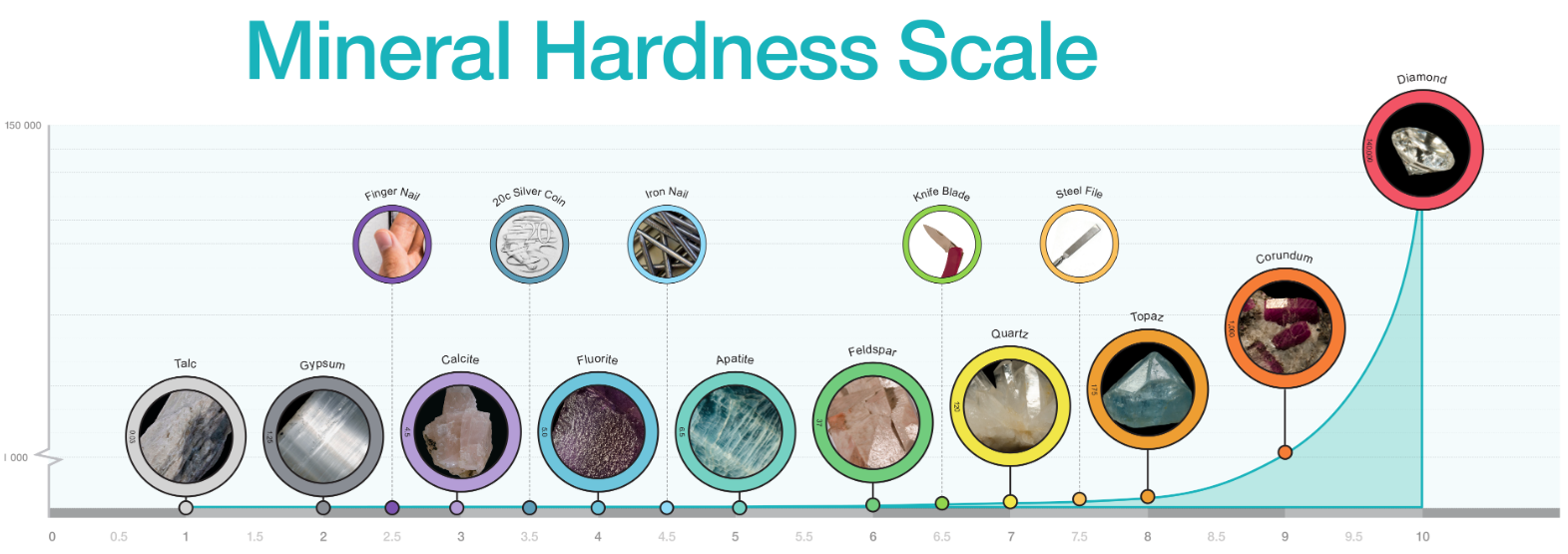
Diagram of mineral hardness comparing Mohs relational scale and Rosiwal absolute hardness. Includes photographs of specimens for each number on Mohs Hardness Scale. Best printed in colour at A3 or larger.
-
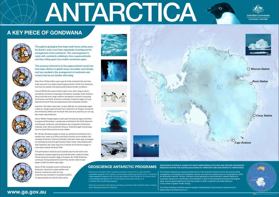
Poster on Antarctica, featuring a large satellite image of the continent with research stations highlighted. Poster also features a geological history of the continent from Gondwana (470 million years ago) including global maps of the shape of the continents through time and accompanying paragraphs of information.
-
This bulk set comprises 10 copies of the Rockhampton River 1:100 000 topographic map and 10 copies of the Jacobs River 1:100 000 topographic map. These are the same maps that are included in the Topographic Map kit, catalogue item # 23002. The maps can also be used with the bulk set of 10 Topographic Map student manuals (catalogue item 30836) and the Introduction to Topographic Maps (catalogue item 23001). Suitable for secondary years 7-12.